THE WINTER WAY OF ST. JAMES - THE ROUTE BY RIBEIRA SACRA
Choose a Language
(Translation done from Spanish with Google Translate)

The Holy See has decreed the extension of the Holy Year 2021 throughout the year 2022 due to the exceptional circumstances surrounding its celebration due to the covid-19 pandemic.
(Last update: 12-22-2021)
INDEX - WINTER ROAD
.
- The Winter Way .
- Roman roads in their origin .
- Official Declaration of the Winter Way as Xacobea Route .
- Regions through which the Winter Road passes .
- Monforte de Lemos Central Point of the Winter Way .
- Typical Gastronomy of the Winter Way .
- Stages of the Winter Road. Stages 1 to 5 .
- Stages through the Ribeira Sacra .
- Visit to Monforte de Lemos - Closest point to obtain La Compostela .
- Stages 6 to 10 .
- Winter Road through the Bierzo Alto between Astorga and Ponferrada .
.
LEÓN FELIPE
(¡Qué pena!)
¡Qué pena si este camino fuera
de muchísimas lenguas
y siempre se repitieran
los mismos pueblos, las mismas ventanas,
los mismos rebaños, las mismas recuas!
¡Qué pena si esta vida tuviera
–esta vida nuestra–
mil años de existencia!
¿Quién la haría hasta el fin llevadera?
¿Quién la soportaría toda sin protesta?
¿Quién lee diez siglos en la Historia y no la cierra
al ver las mismas cosas siempre con distinta fecha?
Los mismos tiranos, las mismas cadenas,
las mismas guerras,
los mismos farsantes, las mismas sectas
¡y los mismos, los mismos poetas!
¡Qué pena,
que sea así todo siempre, siempre de la misma manera!
To make a pilgrimage to Santiago without repeating the same towns, nor the same windows and flocks, it has been reborn
THE WINTER WAY
ROMAN FOOTWEARS IN THEIR ORIGIN
From Ponferrada, the pilgrim has two options to continue to Santiago, by the Camino Frances (going straight ahead) or by the Camino de Invierno (turning left). Since at least the time of the Roman Empire, the Winter Road has been the natural entrance to Galicia from the plateau. Following the course of the River Sil, the route was followed by different towns throughout history to enter Galicia, from the Romans and French troops, to the railway and the central access by road to Galicia.
To trace the path, several secondary Roman roads were used.
The G-51 road (from Ponferrada to las Médulas through the Cornatel), appears on the Map "Index of Roman Roads and Millennial Paths of Hispania" by Gonzalo Arias.
The G-40 road (it goes through Quiroga, Barxa de Lor, Monforte, Codos de Belesar, Chantada), appears on the maps "The construction of the territory - Historical Map of the Northwest of the Iberian Peninsula" by José Ramón Menéndez de Luarca.
Sections of the Vía Nova or via XVIII of the Antonino Itinerary, which linked the current cities of Braga (portugal) and Astorga (province of León in Spain) and passed through the regions of Valdeorras in the province of Orense and El Bierzo in the province of León ending in Astorga after passing the Manzanal port. It was built to improve trade, between the years 79 and 80 during the empire of Vespasian and his son Titus, by the legate C. Calpetanus Rantius Quirinalis Velerius Festus and restored in the time of Maximinus Thracian and his son Maximus. It was 210 Roman miles (about 330 km) long. Along its route, the Roman miles are marked by "milestones".


NAME'S ORIGIN
This Camino de Santiago has received several names during the process of its approval by the Xunta de Galicia, for example "Camino del Sur". Some even now propose the name "Camino del Sil" because following the Sil Valley in several of its main stages is what makes it different from the rest of the roads and gives it its own personality. It has been given the name of Winter Road because in the Middle Ages, according to data published in the Astorga diocesan archive, many pilgrims used it as an alternative to the French way, to avoid the high peaks of O Cebreiro snowed for months and frequent overflows of the rivers of the Valcarce valley. In addition, in recent years the "Winter Road through Alto Bierzo" between Astorga and Ponferrada, which passes through El Manzanal, Bembibre, San Miguel de las Dueñas and the Bárcena reservoir, has been developed and approved by the Junta de Castilla y León. so currently the Sil is only covered in a few stages.


SMALL AGE OF ICE
After a hot period called the Medieval Climate Optimum (10th century to the 14th century), due to various causes such as low solar activity, increased volcanic activity, ocean-atmosphere interactions, natural climate variability and depopulation of Europe Due to the Black Death, intermittent cold spells occurred that affected the Northern Hemisphere, especially Europe, from the early 14th century to the mid-19th century. There were three lows: one in 1650, another around 1770, and the last in 1850. Millions of people died from the cold. Huge glaciers spilled across Europe, rivers remained frozen for a long time, and Eskimos could kayak down to Scotland.
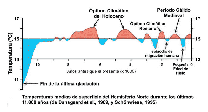

The Little Ice Age aggravated the winter problems in O Cebreiro, heavy snowfalls throughout the winter and therefore more thaw during spring and more floods in the Valcarce valley. In conclusion, although the Little Ice Age contributed to reducing the total number of pilgrims to Compostela, the relationship between those who went on the winter path and the French increased in winter and spring. Every pilgrim who traveled in winter and spring was practically obliged to follow the Sil path to Quiroga and cross the Sil in the various existing boats to San Clodio, continue along the left bank of the Sil to A Cubela, cross the Sil river by boat to Barxa and from there to Monforte, Belesar, Chantada, Lalín, Santiago.
It is currently used at any time of the year
to contemplate the fantastic places through which it runs,
full of nature, monuments and wonderful landscapes.
VAL DO FRADE IN AUTUMN


On the same day 11-28-2021, Piedrafita del Cebreiro on the French Way was like this:


(Piedrafita photographs taken from the Facebook group "Secret places of Galicia")


According to data provided at the end of December 2019, by Nava Castro (Galician Tourism director) in Monforte de Lemos, the influx of pilgrims on the Winter Way has tended to rise since its official recognition. Until the beginning of December, it was visited by more than 1000 pilgrims, which represents an increase of more than 50% with respect to the statistics of 2018.
WINTER ROAD RECOVERY
THE STATE OF LEMOS
In the late Middle Ages, the State of Lemos was created by the hand of the Condal House of Lemos, which has been the most powerful secular state in the Kingdom of Galicia. Until its final disappearance at the beginning of the Contemporary Age (Regency of Mª Cristina de Borbón), this State has played a decisive role in the historical development of the Kingdom of Galicia and Spain and therefore, in the international concert of the Modern Age ,.
The State of Lemos extended throughout the eastern part of the current Autonomous Community of Galicia crossing it diagonally from south to north and whose capital and central nucleus (Monforte de Lemos) was located in the Land and Valley of Lemos that according to doctor D Sebastián Miñano and Bedoya it was "a generally fertile terrain, although interrupted by mountains" and the Lemos valley was "the most populated and richest of all there is in Galicia ."
The Lemos valley is an area between the Sil and Miño rivers and is crossed by the Cabe river and its tributaries, hence its fertility. It was the place chosen by the kings of the Middle Ages (first using monks and then military orders and nobility) to settle a population of migrants that would allow them to exploit their agricultural and mining wealth. Its subsequent growth will allow the creation of a powerful LAY STATE . Said State depended on the jurisdictional lordship of the Count or Countess of Lemos with functions of government and administration of justice, civil and criminal in the first instance, over all the people of the plain state residing in it.
The Counts of Lemos also held the title of Marquises of Sarria (16th century) and the jurisdictional lordship of Paradela and a large part of the Somoza Mayor de Lemos.

Consequently,
a network of roads was created that concurred in Monforte de Lemos,
which were used by pilgrims to Santiago
when the weather conditions on the French road were adverse.
Therefore:
the State of Lemos controlled several of the pilgrimage roads or routes to Santiago de Compostela
that crossed the current province of Lugo,
including:
The so-called WINTER ROAD that entered Galici following the course of the river Sil, with various variants but, all of them had as a reference and concurred in Monforte de Lemos.
The so-called FRENCH ROAD for being the Counts of Lemos marquises of Sarria (16th century) and lords of Paradela and a large part of the Somoza Mayor de Lemos.
Ergo, by virtue of the assertion that "each pilgrim makes his way"
Various routes can be established through the regions through which the winter road runs.
Which of them should bear the qualifier of "Official Route"?
In other words, in which of them should Official Bodies invest part of their budget?
REQUIREMENTS FOR A ROUTE TO BE OFFICIALLY DECLARED
CAMINO DE SANTIAGO THROUGH THE XUNTA DE GALICIA
For a route to be officially declared as the Camino de Santiago, it is considered necessary to present documents in which the following elements are justified:
The route has a documented history of the passage of pilgrims. For example, reception centers for walkers through hospitals or shelters.
The route has a documented history of its influence on the structuring, conformation and characterization of the territory it crosses.


Other documents that favor the official declaration are: there were Roman roads before they were pilgrimage routes, archaeological remains, specific signs, cults and places related to the pilgrimage have been found, such as: toponymy, local traditions, archival documentation, ordeporic literature (treats of the events and things seen during a trip, stories of pilgrims that are preserved), literary texts, historical cartography, etc.
OFFICIAL DECLARATION OF THE WINTER ROAD AS A XACOBEA ROUTE
The Winter Road was not included as an official route initially. Víctor Vázquez Portomeñe declared in the "XVI Scientific Xornadas do Camiño de Inverno" held in Monforte de Lemos from September 13 to 15, 2019, that he did not dare to include it because it was not documented and for fear of being criticized politically because, he is from the Chantada area through which the winter road passes.

In 1998, with Mr. Nazario Pin being mayor and Ms. Aida Menéndez Lorenzo councilor for culture, the Monforte de Lemos City Council received a proposal to carry out a study on a road to Santiago that, according to Elías Valiña, followed the course of the River Sil to the south of the province of Lugo.
In 1999, the Monforte de Lemos City Council agreed to dedicate 3,500,000 pesetas for the preparation of a report that endorses the existence of a Jacobean route that passes through Monforte and entrusts Dª Aida Menéndez with the management of the entire process.
The research works are carried out by a committee directed by the history professor Ramón Izquierdo Perrín. According to Perrín, the route would enter the province of Lugo through Montefurado and would follow the course of the Sil river to Quiroga. Then it would follow San Clodio, Torbeo, La Cubela, Rozavales, Villamarín, Monforte de Lemos, Belesar, Chantada, Lalín.
On April 28, 1999, an association was created with the municipalities through which the route passed: Quiroga, Ribas de Sil, Puebla del Brollón, Bóveda, Monforte de Lemos, Pantón, Saviñao, Chantada. The association is registered in the registry of promoting entities of the Caminos de Santiago with the number 102 and the name of "Asociación Camiños a Santiago pola Ribeira Sacra". Aida Menéndez is the president and continues to be so to this day.
In 2004, the association was opened to private members and in 2020 it had about 400 members.
Representatives of the Bierzo, Valdeorras and Deza regions are contacted to join forces in achieving the official declaration of the Camino de Invierno com Ruta xacobea.
For more information on the long road traveled to obtain the official declaration, see the website of the association whose URL is at the bottom of this page.
ADMINISTRATIVE ORGANIZATIONS
The section between Ponferrada and Puente de Domingo Flórez is located in the Community of Castilla-León and, therefore, the Junta de Castilla-León is the administrative body that can regulate it.
The stretch from Puente de Domingo Flórez to Santiago is located in Galicia and therefore the Xunta de Galicia is the administrative body that can regulate it.

OFFICIAL RECOGNITION OF THE WINTER ROAD
BY THE XUNTA DE GALICIA
The Galician Cultural Heritage Law, Law 5/2016, of May 4 (BOE of June 18, 2016), after the studies carried out to prove the path, officially recognizes the Winter Path (in the section under its jurisdiction, from Puente de Domingo Flórez to Santiago) as a pilgrimage route on the Camino de Santiago.
Likewise, the new law includes the initiation of the BIC declaration of a Xacobea Route if the municipalities through which it runs unanimously request it, which improves its protection and conservation.
On the other hand, the regulations allow the establishment of an integrated territorial plan of the Caminos de Santiago to improve the effective protection of the Camino de Santiago.
RECOGNITION OF THE WINTER ROAD
BY THE COMMISSION OF THE ROADS TO SANTIAGO BY CASTILLA Y LEÓN
The Commission of the Roads to Santiago by Castilla y León is the collegiate body, attached to the Ministry of Culture and Tourism, that coordinates the actions related to the Camino de Santiago in the territorial scope of the Community of Castilla y León, and in the that the different councils of the Junta de Castilla y León, the provincial councils, the municipalities of Los Caminos, the Dioceses of the Community and the associations whose associative purpose is the promotion of the Jacobean routes are represented, as well as people who have accredited a relevant knowledge on the Roads to Santiago.
On December 21, 2020, the Commission of the Roads to Santiago by Castilla y León, chaired by the Minister of Culture of the Junta de Castilla y León (Mr. Javier Ortega), has favorably reported the recognition as the Camino de Invierno Historical Path on its way through Castilla y León (from Ponferrada to Puente de Domingo Flórez).
The Commission recognizes its historical value and ponders the fact that it is already recognized and declared an Asset of Cultural Interest in the Community of Galicia. It is also valued that it is a well-marked route and that it has infrastructures and resources for pilgrims.
A path is considered to be historical, if it has been associated with the pilgrimage of the pilgrimage, it has been an established trade or transport route and values of cultural interest have been added.


REGIONS THROUGH THE WINTER ROAD PASSES
The route established by the association "Camiños a Santiago pola Ribeira Sacra" and maintained by the Xunta de Galicia, is divided into ten stages that total 262 kilometers as reflected in the following map:

The Winter Way passes in León through the Bierzo region and in Galicia through the regions of: Valdeorras, Quiroga, Tierra de Lemos, Chantada, Deza and Santiago.
I put the regions because there are places of natural, cultural and tourist interest that, without being within the winter road, are in their vicinity and can or should be visited.


COMMUNITY OF CASTILLA Y LEÓN
PROVINCE OF LEÓN
The road passes through the region of El Bierzo, begins in the Burgo de Puente Boeza de Ponferrada (it emerged in the 11th century as a settlement around the Camino de Santiago and its valuable historic center should be visited). Then it goes through the following towns:
Toral de Merayo (with the church of "El Salvador"); Villalibre (popular architecture); Priaranza (houses with corridors and wooden balusters); Santalla (balcony of the Bierzo); Villavieja (with the church of Santiago); Cornatel Castle (belonging to the Templars and later to the Counts of Lemos); Borrenes (crossroads where a Pilgrim Hospital was built).


Then we arrive at Las Médulas (considered the largest open-pit gold mine in the entire "Roman Empire." The extraction of the mineral altered the environment, resulting in a landscape with spectacular shapes and colors, currently partially covered by chestnut trees and oaks They have been declared "Asset of Cultural Interest" in 1996, in view of their archaeological interest, they have been declared by Unesco "Heritage of Humanity" in 1997 and "Natural Monument" in 2002, they have been considered as one of the ten most impressive natural corners of Spain in 2016.); Mirador de los Pedrices (magnificent views of the mines and town of Las Mádulas).

You leave the province of León by Puente de Domingo Flórez (gate charge to cross the bridge over the Cabrera river).


GALICIA COMMUNITY
The winter road is the only road to Santiago that crosses the four Galician provinces.
ORENSE PROVINCE
In the province of Orense the road crosses the region of Valdeorras and passes through the towns of: Quereño; Pumares; Override it; Entoma; Valdeorras-Xagoaza boat. From Xagoaza you pass Tremiñá; Arches; Villamartín de Valdeorras and la Rúa.


Between Quereño and El Barco there is a variant that passes through the Sierra de la Encina natural park through Sobredo, Biobra, Robledo, Rubiá).


PROVINCE OF LUGO
lIn the province of Lugo, the Camino crosses the regions of Quiroga, Tierra de Lemos and Chantada and passes through the following towns:
Municipality of Quiroga: (Albaredos; Montefurado; (mountain perforated by the Romans); Bendilló; Soldón; Cospedro; Quiroga; Hermitage of Los Remedios; Carballo de Lor).
Municipality of Puebla del Brollón: (Barxa de Lor; Castroncelos; Vilarmaos; Puebla del Brollón; Cereixa; Ráiros).
Municipality of Monforte de Lemos: (Reigada; Rioseco; Monforte de Lemos (its old part has been declared a Site of Cultural Interest), A Vide, Campos
Municipality of Saviñao: (Pazo de Regüengo, Piñeiro, A Barxa, Fontela, Diomondi).
Municipality of Chantada: (Puente de Belesar, San Pedro de Líncora, Chantada, Centuye, Lucenza, Vilaseco, Monte del Faro (from which landscapes of the four Galician provinces can be seen).
From Quiroga to Monforte there is a variant that passes through Sanclodio, A Covela and La Ribeira Sacra (Asset of Cultural Interest); Vilachá de Salvadur, Rozavales; Villamarín; Santa Mariña do Monte and Monforte.,.


PROVINCE OF PONTEVEDRA
In the province of Pontevedra, the Camino crosses the Deza region and passes through the towns of: Rodeiro, Lalín, A Laxe and Silleda; Ponte Taboada, Bandeira.


PROVINCE OF LA CORUÑA
In the province of La Coruña, the Camino enters the Santiago region and passes through the towns of: Puente Ulla (Coruña area); Rubial; To Susana; Santa Lucia and Santiago de Compostela.


MONFORTE IS IN THE CENTRAL POINT OF THE WINTER ROAD
From Ponferrada to Monforte the road is 129 km long.
From Monforte to Santiago the road is 133 km.
In Monforte is
the Winter Way Interpretation Center.

OBTAINING "LA COMPOSTELA"
For the youngest, the oldest and the least walking, Monforte is the closest point to Santiago that allows obtaining the “Compostela” (a document granted by the Cathedral Council of Santiago to prove that the pilgrimage to Santiago has been made for religious reasons or spiritual).
FOR INSTANCE:


Pay attention that both the sealing dates of the credential and the date of the Compostella granted by the Cabildo Compostelano are from 2010, six years before the official recognition of the Winter Way by the Xunta in 2016.
TYPICAL GASTRONOMY OF THE WINTER ROAD
The regions through which the Winter Way runs have an excellent typical gastronomy, which can be tasted in the various towns of each region where a stage ends, as there are restaurants and hotels in them. However, as the Winter Way runs through areas of depopulated Spain with magnificent landscapes and natural resources, in many of the intermediate towns there are no restaurants or bars, so you should take a basic meal and drink along the way. When choosing this basic diet, I think it's convenient to remember some popular sayings.
POPULAR SAYINGS
"Water, bread, wine and olive oil are sources of life"
"With bread and wine walks the way"
"Bread and wine is on the way, no garrido waiter"
"The duels (penalties) with bread are less"
"With bread, wine and cheese, there is no stiff path"
"Good wine resuscitates the pilgrim"
"Galician cold, slice of wine"
"A good hunger no hard bread"
"The beggar asks for bread, but he eats meat if they give it to him"
"Without land and olive groves, what would be the cities"
We will see the typical gastronomy on another page.
STAGES OF THE WINTER ROAD
ROUTE PLANNING
In order not to get excessively exhausted and to avoid getting lost if it gets dark, the stages should be planned, adjusting them to the conditions of each one, especially in winter because the weather conditions are harsher and the days are shorter.
Because currently, to spend the night you have to adjust to the places where there are hostels, pensions, hostels or hotels, the stages established by the road associations are, in my opinion, too long. Consequently:
each pilgrim will divide the path into the number of stages that suit their conditions,
If an official stage, for whatever reasons, is too hard or long for him to do in a single day, he will divide it as he sees fit. There may also be pilgrims (there are) who wish to group several stages totally or partially. In fact, the different associations of the path do not totally coincide either in the duration or in the number of stages.
To obtain the Compostela or the Accreditation Diploma,
the only important thing is that, when starting a stage
the accreditation is stamped in the same place where the previous stage ended.
On the other hand, within the official roads, there are some sections that have several options, each pilgrim will choose the one they deem appropriate and even,
if you want to visit a place that is not included in the official routes
(for example, the most impressive areas of the Sil canyon),
take one or more days off to visit with peace of mind
interesting places for their nature, their culture or their monuments,
DO IT AND CONTINUE THE ROUTE WHEN YOU CONSIDER IT OPPORTUNITY.
The Camino de Santiago is not to beat hiking marks, it has other objectives,
as I have been relating throughout the WEB pages that I dedicate to the Camino de Invierno to Santiago.
Since the efforts to ensure that the route between Ponferrada and Santiago de Compostela, following the course of the Sil River, was considered as the Official Camino de Santiago by the Xunta de Galicia and the Commission of the Roads to Santiago by Castilla y León, the The unofficial route of the various stages has undergone numerous changes.
In the Xacobeo 2021 Strategic Plan it is said that it should not be only a plan of the Xunta and that it is necessary to involve Town Halls, Provincial Councils, the Church, Associations and in general the Galician citizens, which must acquire prominence and participate actively promoting own initiatives.

On 8-10-2021, the Galician Parliament unanimously approved a resolution urging the Xunta to complete the delimitation of the Camiño de Inverno route.

The Xunta, faithful to the spirit of the Xacobeo 2021 Strategic Plan, considers that there has not been enough synergy between the different groups and that there are numerous controversies about the layout of the stages, therefore, it awards a contract to "Valora Management Consultants" to establish a new Master Plan with a view to the Xacobeo of 2027 and obtain the final official layouts.
The new roadmap for 2027 will seek to create a coordination plan between institutions linked to the Jacobean route. It will include several autonomous departments, the Church, the provincial and local public administrations, the Friends of the Camino de Santiago associations, social agents and various Spanish and European institutions.

As Monforte de Lemos is at the midpoint of the Camino de Invierno route and being the closest town to Santiago at a distance of more than 100 km, to obtain La Compostela or the accrediting Diploma, it will be enough to make the way from Monforte de Lemos to Santiago de Compostela. For this reason, we will divide the total winter walk into two parts: the first from Ponferrada to Monforte de Lemos and the second from Monforte de Lemos to Santiago de Compostela. The strongest can make it all the way from Ponferrada but the least walkers can make a tourist visit to the first leg and start walking during the second leg.
The Xunta has not yet established the official route of the Camino de Invierno and has been given until 2027 to establish it.
I think that the road between Ponferrada and Santiago should be divided into at least 12 stages, six from Ponferrada to Monforte and another six from Monforte to Santiago.
PONFERRADA SECTION - MONFORTE DE LEMOS
Due to historical fidelity and beauty, the stage of the Winter Road between Quiroga and Monforte de Lemos must pass through the meander of La Cubela, but current politicians have been unable to solve the Sil crossing through that place (something that they had solved with a boat in the Middle Ages and two boats in the 18th century) and promote an alternative through Puebla del Brollón that departs from the Sil river and has neither the historical foundations nor the beauty of the route through La Cubela. The route through Puebla is a stage like those of the French Way, the route through the Cubela is possibly the most beautiful route of all the stages of all the existing Camino de Santiago in Spain.
On the page to which the following link takes us, I present the possible alternatives for the Quiroga - Monforte route, proposing an intermediate route between the previous two, shorter than that of the politicians, with more historical foundations and much more beautiful. Follow the path of the river Sil for 14 km and circulate through the beginnings of Cañón del Sil and the vineyards in terraces of the banks of Vilachá: Eibedo, Val do Frade and Lagares.
STAGES BY THE RIBEIRA SACRA

The winter road passes through the Ribeira Sacra in the sections:
Quiroga-Monforte following (the alternative route: Quiroga - San Clodio - A Cubela - Rozavales - Villamarín - Monforte de Lemos) or (the route Quiroga - San Clodio - Augas Mestas - Abelaira - Rozavales - Villamarín - Monforte de Lemos).
Monforte de Lemos - Chantada.
The team led by Ramón Izquierdo Perrín established the following route between Quiroga and Monforte:
Quiroga - San Clodio - Augas Mestas - Torbeo - A Cubela - Barxa - Vilachá - Rozavales - Villamarín - Monforte
Initially, the Quiroga - San Clodio - Augas Mestas - Torbeo - A Cubela sections were signposted and continue to be signposted as Camino de Invierno.
TOURIST VISIT TO MONFORTE DE LEMOS
PILGRIM HOSTELS IN MONFORTE
Hostel Santiago 15
Privately owned, it is located on Calle Santiago No. 15, it has 50 places with closed bunk beds distributed in shared rooms in 4 modules. It has 50 seats because 50 seats are what a bus has. It provides a buffet-style breakfast service and offers tourist activities: city visits, hiking or cycling routes through the Ribeira Sacra, wine tourism, etc.


Lemavo Hostel
Privately owned. Located at 55 Chamoso Lamas street in the Las Cruces neighborhood.
It has fifteen places, divided into a room with six beds, another with four, one more with three and one with two.
At present there is no public hostel in Monforte, which according to some hiking WEBSITE, CLAM HEAVEN !.
I hope that the Monforte City Council will remedy this deficiency as soon as possible.
WINTER WAY THROUGH BIERZO ALTO
RECOGNITION OF THE WAY THROUGH THE MANZANAL
BY THE COMMISSION OF THE ROADS TO SANTIAGO BY CASTILLA Y LEÓN

The Commission of the Roads to Santiago by Castilla y León is the collegiate body, attached to the Ministry of Culture and Tourism, that coordinates the actions related to the Camino de Santiago in the territorial scope of the Community of Castilla y León, and in the that the different councils of the Junta de Castilla y León, the provincial councils, the municipalities of Los Caminos, the Dioceses of the Community and the associations whose associative purpose is the promotion of the Jacobean routes are represented, as well as people who have accredited a relevant knowledge on the Roads to Santiago.
On December 21, 2020, the Commission of the Roads to Santiago by Castilla y León chaired by the Minister of Culture of the Junta de Castilla y León (Mr. Javier Ortega), has favorably reported the recognition as the Traditional Way of the Winter Way through the Manzanal (Bierzo Alto).
A path is considered traditional if it has performed a complementary function in the pilgrimage to Santiago and they have been and continue to be structuring axes as they pass through the Community of Castilla y León.
The traditional French Way, to save the mountains that separate Astorga from Ponferrada, ascends through the port of Foncebadón which in winter usually suffers frequent snowfalls.
Traditionally, there is another possibility following the Vía Nova or Vía XVIII de Antonino through the Manzanal port, which is a much smoother route with a milder climate in winter.
This second route passes through the towns of Bonillo, Combarros, Quintanilla, Velvedo, Manzanal del Puerto, Montealegre, La Silva, Torre del Bierzo, Bembibre, Almázcara, Matachana, San Miguel de las Dueñas and Ponferrada. It is 60 kilometers and practically the entire route coincides with the N-VI road.
This route is known today as the “Winter Road between Astorga and Ponferrada” and there are numerous initiatives by Town Councils, Neighborhood Councils and Associations of the Region to be officially recognized.


ME VOY
(LEÓN FELIPE)
Me voy porque la tierra ya no es mía,
porque mis pies están cansados,
mis ojos ciegos,
mi boca seca
y mi cuerpo dócil y ligero,
para entrar en el aire.
Me voy porque ya no hay caminos
para mí en el suelo.
Salí del agua, he vivido en la sangre
y ahora me espera el Viento
para llevarme al sol…
Salí del mar… y acabaré en el fuego.
Other WEBs